Day 4
Sunday, 8/15/2021
Numerous mornings on this trip I’ve looked at the clock and debated getting dressed and heading out for sunrise. Most other morning I’ve simply rolled over and gone back to sleep.
Today was different. I had the bonus of a lake and the promise of some reflections. With the lake being just a few steps from the motel's lounge area, how could I pass it up.
The staff was still setting up the Continental Breakfast when I walked through. The coffee was ready, so I was good to go. The desk staff even told me I had access to the paddle boats, canoes and rowboats if I chose. Instead, I stood on the shoreline, sipping coffee and watching the pink develop on the horizon. Occasionally a duck would swim by, or what looked like a beaver. Add all the bugs on the water, and I pretty much had the place to myself. No complaints.
There are trips with plenty of time to do through research. Then there’s this trip. In looking for waterfalls, I came across Lake of the Falls. It’s the reason I overnighted in Mercer. It was an easy drive north and a few miles on out on County Road FF. Or so I thought.
As I drove down the county road, I passed a few “resort” type places that seemed more like cabins with a central general store. Nothing special. Suddenly, I encountered this…
Looking at the map on Google, it seemed like the only public access was on the very far side. It seemed a bit involved, and a further drive than anticipated.
Instead, I punched the next destination into the GPS to get me out of all the smaller roads. It got me back out to Hwy 51. Then things got a little interesting.
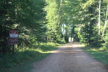
Apparently, my GPS had found a shortcut to the state park where I was headed. It involved over thirty-five miles of dirt and gravel roads. I didn’t know this at the time. I followed along since it said seven miles. That turned out to be the first intersection. That’s where I saw this…
That’s also where I pulled out the phone and did a google search for the state park. I had enough of a signal that I could tell, this would be a long detour. So, I cut my losses and turned around. That’s when I saw the rough road sign.
Seven miles later, I was back on pavement. The added bonus of this was a trip through Hurley. That’s where you’ll find the World’s Biggest Corkscrew. Perfect for the World’s Biggest bottle of wine. You can find that in Lyssach, Switzerland. It’s stands over thirteen feet tall and holds 817 gallons of wine.
The goal for the day was Copper Falls State Park. Once I finally arrived, minus the rough shortcut, I paid my day use fee and drove out to the parking lot by the concession stand.
From there, you pick up the two mile round trip Doughboy Trail. It’s a well maintained loop trail with a few side options. I chose to go counter clockwise and over the bridge first…
You don’t go very far an there’s a side trail to the observation tower. It’s not a long trail, but I counted 143 stairs. Then it’s a short walk to the tower.
Eighty steps further and you get a view of the tree tops.
Back on the main loop trail to Copper Falls. The name has nothing to do with the metal, just the color of the water flowing over the falls.
Keep walking the loop and you get to Brownstone Falls...
I left the park early in the afternoon. By the time I pulled into Ashland, I was seriously thinking lunch. Being Sunday, many places were closed for the day, opening late or closing early. That’s how I found myself at the Ashland Family Restaurant. There were two bar and grills open, but I needed something different. The Cajun Chicken Salad fit the bill.
Many cities have murals. As you drive up and down Main Street, there are plenty pf murals here as well. Some offer a glimpse at Ashland’s history. This one was hard to miss.
I left Ashland late in the afternoon. Bayfield was forty minutes away. I parked downtown to get an idea of where I had to go in the morning, taking a few shots along the shores of Lake Superior.
Seen around downtown Bayfield...
From downtown, I punched in the address for Adventure Club Brewing into the GPS and drove out. I would have sworn the brewery was south, but my GPS sent me north. In the end, I unplugged it and referred to Google instead. After all, I was headed in the wrong direction, and it tried to send me a mile down this road.
I would eventually find the brewery. They have a dog friendly beer garden out back. Some dogs played. Others barked. But, they seemed go be having a good time, too. As for the brewery, in the front is a store that sells hiking, camping and all sorts of outdoor gear.
My home for the night was three miles back down the road. I had rented a condo for two nights. Motels in Bayfield were a bit high, and I read some sketchy reviews of a few motels further out. No complaints It was the size of a large motel room anyway. While unpacking the car, I met the building manager. From talking with him I got the impression that quite a few of the units are simply rentals.
It’s also a five minute walk to the harbor. I wasn't expecting much from sunset, but walked out anyway.


No comments:
Post a Comment