Monday June 18
When I planned
this trip, I knew there would be that one day where I would be in the car the
entire day. It couldn’t be avoided. I was going from Point A to Point B and there
really isn’t much in between. With that
in mind, I did get an early start.
5A and I’m packing
the last of my stuff into the car. A
quick stop at the front desk and I am on the road. I picked up Hwy 2 South, and rolled off the
miles.
Surprisingly, the
coffee in the motel’s breakfast area was
pretty bad. Does anyone still
drink Nescafe anymore? So, I didn’t take
a cup with me. It was the perfect excuse
to stop a half hour down the highway in the town of North Pole. The highway ramp drops you directly on Santa
Clause Lane. And yes, their street lights are painted like candy canes.
Caffeinated, I
continued south, past Eielson Air Force Base. The road parallels the
runway. There were plenty of F-16’s and
A-10’s as well as a larger plane I didn’t recognize. The signs along the highway clearly state No Parking, No Stopping and No Photography. I drove on.
The base is named after Carl Eielson. As a kid, he was fascinated by planes and signed up to be a pilot for the U.S. Army Signal Corp during WWI. The war ended while he was still in training. He returned to North Dakota and started the Hatton Aero Club, the first aviation club in the state.
While attending Georgetown University and working part time as a Capital Hill Police Officer, he met one of the delegates from the Alaska Territory. He convinced Eielson to come to Alaska to teach.
While there, he formed the Farthest North Aviation Company and started delivering Air Mail between Fairbanks and McGrath. What previously took dogsleds twenty days to cover, he could do in four hours. Before dying in a plane crash seven years later, Eielson became the first pilot to land and take off from a drifting ice sheet and the first to fly over the north and south pole in the same year. There's a reason so many things up here are named after him.
Walking back to
the car, I saw this shoe hanging there, ankle strap broken and bow torn.
Something tells me this shoe has a story to tell.
North of Delta
Junction, I crossed this bridge. The bridge in back carries the Trans-Alaska
Oil Pipeline.
Further up the
road is a large pullout, where you can walk right up to the pipe. Though the
signs clearly state, “Please don’t climb on the pipe.”
After making the
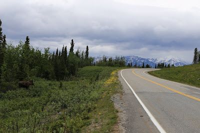
turn south on Hwy 4, I pulled off when I saw a moose up ahead. I took a few shots, then retreated back to
the car to get out of the wind. I waited
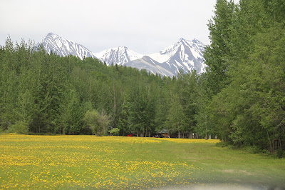
for a while, hoping he would stroll a little closer to the road. I was imagining the framing with the yellow
flowers and the white mountains. Sure,
the yellow flowers were just dandelions, but it could have been an interesting
shot. Instead, he just wandered into the trees.
It was around 1P
and I was thinking food. I passed a
placed called Grizzly Pizza. I wasn’t
thinking pizza, but I felt compelled.
Perhaps it was the Clydesdale on the roof.
There was one
other customer there, John. He’s a
wildlife biologist here studying bears. He grew up in North Dakota. I told him
about my vacation there a few years ago. He’s been to forty-nine states and looking for a reason to go to Florida
to complete the fifty.
I also met
Marianne. She and her husband Bill own
the place. They bought it in 1977 and settled down here. She told me I was just a few weeks from the bear migration. When the salmon
appear, they come down from the mountain and head to the river. It’s a regular site to see them stroll on by
outside. The thing is, the salmon are late this year and no one really knows why. Marianne and Bill throw an annual Summer Solstice Party here and serve a lot of salmon. Perhaps not so much this year. I didn't meet Bill. He was down at the river checking the salmon, or lack thereof.
Ten miles further
south is the turnoff for Chitina.(pr; CHIT-nuh) The first thirty miles looks a
lot like this….
On the back end
of town, it all changes. The next sixty-one miles is what they call The
McCarthy Road. There’s a reason some
rental car companies won’t allow their vehicles on the road. I
later learned, as expected, the road condition deteriorates through the more
heavily trafficked season. Repairs used
to be done quickly from Chitina, but they lost their funding. Now the crews have to come from Glenallen,
another eighty miles away. So, it gets bad and stays that way.
Right away, it
becomes evident that this did indeed used to be the rail bed for the Copper
River and Northwestern Railroad.
The road itself
goes from decently paved to paved with potholes, decent gravel, washed out
gravel to smooth dirt, then back to more potholes of random sizes. The speed limit is thirty-five, and for good
measure. You really can’t take your eyes
off the road directly in front of you.
It made for a mind numbing two hour drive.
And this
abandoned railroad trestle built a year later.
It was built in eight days, in the dead of winter.
Finally, I made it to the end of the road and the River View Lodge.
Not a bad view from the room…
That pile of dirt in the center of the shot is actually the toe of Kennicott Glacier.
Not a bad view from the room…
That pile of dirt in the center of the shot is actually the toe of Kennicott Glacier.
I had a nice chat with Brad who runs the
place. This is as far as I can take the
car. The Park Service runs a regular
shuttle from the end of the road(a five
minute walk) to the visitor center. More
on that tomorrow. It was already after
5P when I checked in, and I was just pretty much done for.
The Lodge doesn’t
offer food, but it does have a kitchen.
No problem, I had plenty of fresh fruit and Clif bars for the next few days. However, downtown McCarthy(population 28) does
have a couple of restaurants. That’s
fifteen minute walk. This is from the footbridge.
If you’re walking, you do have to cross this as well...
If you’re walking, you do have to cross this as well...
Apparently, the
beavers have been building up their dam, which causes the road to periodically
flood. While not a big fan of water
crossings in general, I did learn in Denali that my boots are indeed
waterproof. Fortunately, there are a few decent sized and well placed stepping stones on the far right, just not enough.
There isn't much to downtown McCarthy.
There's a cafe, a restaurant and a place called the Golden Saloon. I later learned the locals just refer to it as "the bar." By this point in the trip, I was really tired of bar food. I picked the one thing that was completely different. I’ve never had Pho before. It's a Vietnamese soup with chicken and noodles. It was pretty good, but there was something about it that just didn’t work for me. I’m glad I tried it, but once was enough.
Coming Up,
Regrets, I had two


No comments:
Post a Comment