Day 23
Sunday June 24
There were just three things on the
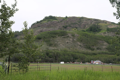
docket for the day, and they were quite diverse. The first was a hiking trail up Bodenburg
Butte. This trail was recommended on
numerous sites, so I decided to add it to the trip. It’s an easy drive south of Wasilla and a few
miles out Old Glenn Highway. The road
crosses the Knik River alongside the original bridge, which closed to traffic
in 1973. It’s blocked off for anything
but pedestrian traffic.
The website I used said to turn off on
Bodenburg Loop Road. It wasn’t clear
that I wanted to take the SECOND part of the loop road. Either one will bring me to a parking lot for
the butte. So, I would up in the
parking area for the south approach. The
second turn into Bodenburg Loop consequently would bring me to the north
approach.
According to the website, the north
approach is better maintained and significantly less steep. I cobbled together my day use fee($3) out of
a dollar bill and random change and ditched the car.
Of course there was the seemingly
inevitable guy playing with his drone. He
was flying it out pretty far. I asked
what happens if it goes too far. He told
me the new drones have a function that automatically beings them back to their
starting point if they lose connection or start running out of battery power.
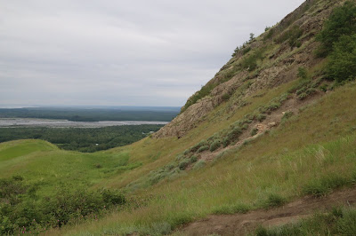
Climbing down the butte was an interesting
prospect. Climbing up, I had the luxury
of stopping and surveying the various routes ahead. Coming down, you can only see so far. Sometimes I chose wisely, but not every
time. It did feel good to be down at the
parking lot again.
Just for kicks, I did drive up the
northern segment of Bodenburg Loop. I
even found the parking lot. I fired off
an email to the hiking website when I eventually got in and suggested they
clarify it a bit.
And eventually the highway. I drove perhaps ten miles east before coming
to the turn off for Independence Mine. I
visited eleven years ago. It was a
beautiful day at the turnoff, but turning foggy as I drove up to the site
From the parking lot… BTW it was forty-one
degrees. Loved it!
Gold was discovered here in 1897. Stakes were claimed and mining began. The Independence Mine was part of the Willow Creek Mining District and the most profitable. It was second only to the mine outside Juneau for gold production, pulling 141,000 troy ounces of gold out of the earth. Translated into standard ounces, that's 155,000. But, consider this, for each ounce of gold, they processed about one ton of ore.
The Independence Mine opened for business in 1934. During WWII many mines were shut down by the government as unnecessary. This one remained open, but was temporarily shut down in 1943, before reopened after the war. In addition to their regular duties, the mine workers were trained with rifles and stood guard. The Japanese were occupying two of the Aleutian Islands and no one was really sure of their next move. The mine shut down for good in 1950.
The Independence Mine opened for business in 1934. During WWII many mines were shut down by the government as unnecessary. This one remained open, but was temporarily shut down in 1943, before reopened after the war. In addition to their regular duties, the mine workers were trained with rifles and stood guard. The Japanese were occupying two of the Aleutian Islands and no one was really sure of their next move. The mine shut down for good in 1950.
BTW, that dress is backless. I felt cold just watching them.
There was a tour of the dining hall coming
up, so I lingered in the visitor center chatting with a couple from Wisconsin.
The more they talked, the less doubt anyone could have had they were indeed
from Wisconsin. Their route through the
state included few sites I didn’t have
time for. They also told me about the ice caves when Lake Superior freezes.
The tour took us into the dining
hall. The mine owners knew morale was
important to keeping workers. So, the
treated the kitchen staff extra special.
The head cook had a full apartment above the dining hall. He was allowed to bring his wife and family
to live there, too. His staff were
given larger rooms in the building as well.
Dinner was back at the Last Frontier
Brewing Company.
The Grub Stake Stout fit the bill. That’s where I met Paul. He came to Alaska from Arkansas for work forty years ago and decided to stay. I sipped my beer while he told me of his travels throughout the state. He came to Alaska and took a job on a fishing boat out of Prudhoe Bay. He did that for a few years and confirmed the sun never really sets during the summer. It just circles the sky. And yes, it stays dark through most of the winter. He also worked for an oil company inspecting pipelines and scouting for new places to drill. He told me about one scouting trip that took him in the middle of nowhere.
The Grub Stake Stout fit the bill. That’s where I met Paul. He came to Alaska from Arkansas for work forty years ago and decided to stay. I sipped my beer while he told me of his travels throughout the state. He came to Alaska and took a job on a fishing boat out of Prudhoe Bay. He did that for a few years and confirmed the sun never really sets during the summer. It just circles the sky. And yes, it stays dark through most of the winter. He also worked for an oil company inspecting pipelines and scouting for new places to drill. He told me about one scouting trip that took him in the middle of nowhere.
He recognized a piece of gold mining
equipment alongside the road. Then he
saw an old abandoned road down the hill. So, he followed it. He came across a small mining ghost town
where it appeared everyone had just given up and left. It took him a while to find out the name of
the town and its history.
He also told me about Alaska’s desert. It's the Kobuk Sand Dunes and pretty much in the middle of nowhere.
A few other local guys joined into the conversation and it seemed to go
off in regular tangents. Gabrielle, our bartender, seemed humored by it all.
Coming Up,
Timing the Tunnel


No comments:
Post a Comment