Today didn’t exactly go as planned. I did what I always do when I get up, turn on
the cell phone. It’s a four year old Lg
and sometimes takes a little longer to boot up.
On this morning, it wouldn’t boot up at all.
It was stuck in a start up loop.
Nothing seemed to get it to work again and I couldn’t even turn it
off. The boot up animation just kept spinning. Just what I need on a road
trip.
So, instead of my planned route, which
would have included a nice midday three mile scenic hiking trail, I worked my
way out to Hwy 50. My theory was I had a
better chance of finding a Wal-mart or Target this way. Trying too arrange meet ups without a phone
would be a mess. A cheap burner phone
would do the trick. Besides, there were no Boost Mobile offices nearby.
Highway 50 would take me across West
Virginia. The first half is a four lane
divided highway with the occasional traffic light. No sign of a Wal-mart of Target. The second half I’ve driven before. It suddenly goes to a two lane country road
with plenty of twists and turns. I
remember the beautiful scenery. I also
remember being frustrated at the lack of places to shoot the scenery.
One thing I didn't expect was the snow...
It was early afternoon when I arrived in
Grantville, Maryland. I had passed
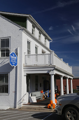
through here a few years ago when I was exploring Maryland. It was too early to check into the Casselman
Inn. But, I went in and asked. The closest Wal-mart was twenty minutes east,
but right off the interstate.
So, I bought a cheap burner phone to get
me through. It felt weird suddenly not having
anyone’s contact information. Crazy how
we get used to this.
There was a reason I booked a room in
Grantville, and it’s just a few miles north in Pennsylvania. The website I use and have trusted up to now
had simple directions. Hwy 219 north to Meyersville then west.
So, I drove out to Meyersville and drove
west. It was a good sign that the road
was going up. Even the dirt section was
in decent shape.
The problem is, the road ended. Frustrated, I backtracked, checking a few
side roads. That didn’t work. One turned into a private road, while another
led to the gate of a mining company.
Stranger still, I hadn’t seen a single
sign.
It was around 4P when I made my way back
to the Cassleman Inn. The inn has been
on this spot since the 1840's.
Downstairs is a restaurant.
Upstairs are the more upscale rooms.
The building across the street are the regular rooms. I was okay with than. My room was spotless and all the furniture
made by a local company.
Since they had given me great directions
before, I asked about Mt. Davis. Their directions were even easier. Two blocks
up, head north. Turn left at Otto’s
Bricks. When the road ends, turn right
and look for the signs.
But first, I hadn’t eaten anything other
than an apple since breakfast. The hotel
has a restaurant that got rave reviews.
The special of the day, spaghetti and meatballs. They make their own sauce and pasta. Fantastic!
Mount Davis sits in the Forbes State
Forest. At 3,213 ft, it’s the highest
point
in Pennsylvania. This makes twenty-two state high points. To get to the summit, there’s even a paved
road. Or, you can ditch your car at the
picnic area and take the .8 mile trail.
After that meal, I figured a nice short
hike would do me some good. Remember
that snow from earlier? Well, here it
had melted and turned the trail into mush.
Still, no complaints.
There’s also a signal tower. The view from above.
A few years ago, I did drive through Grantville. There's a cool, old bridge at the edge of town. The Castleman Bridge was in use from 1813 to 1933.
The view from the bridge...
A few years ago, I did drive through Grantville. There's a cool, old bridge at the edge of town. The Castleman Bridge was in use from 1813 to 1933.
The view from the bridge...
After working my way back to the room, I
registered the new phone and emailed the new number to everyone who would need
it in the next few days.
The weird thing, while I was out shooting the sunset, I could have sworn I smelled maple syrup.
Coming up,
A Little Too Ironic
Coming up,
A Little Too Ironic


No comments:
Post a Comment